Detail Zmax.Net
Network Generation
Z-Max®.Net GPS survey system offers NTRIP, GPRS and RTCM V3.0 network communication. Z-Max.Net delivers high real-time accuracy and enhanced performance for all your survey needs.
Survey Your Way
The ultra-flexible Z-Max.Net survey system lets you control your survey your way. Whichever configuration you chose, Z-Max.Net adapts to your survey environment and delivers the best performance. Z-Max.Net frees you from typical equipment limitations and keeps you ahead of the industry.
* Survey in NTRIP, VRS or FKP networks.
* Select your communication mode: UHF, GSM/GPRS, unique combined UHF+GSM/GPRS module or external source.
* Switch seamlessly from post-processing to RTK.
* Use ZMax.Net as a base or rover.
You can perform any GPS survey with Z-Max.Net.
Survey with Added Freedom
The innovative design offers comfort and ease-of-use. Detachable modules make configuration changes and system upgrades simple.
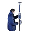
Use the intuitive keyboard or Bluetooth® wireless field terminal to perform any survey with added freedom. Configure your Z-Max.Net "all-on-the-pole" or in the comfortable backpack for long-duration missions.
The modular design and flexibility makes upgrades easy and cost-efficient, protecting your investment and ensuring a high return.
Get the Max Out of Your GPS
Z-Max.Net delivers the strongest RTK on the market. A combination of unique technologies from Magellan enables you to optimize your time and maximize your profit. Z-Max.Net offers two-second initialization, extended operation up to 50 km (30 miles) and cuts static data collection time by up to 50%.
* Patented Z-TrackingTM and advanced multipath mitigation technologies ensure the strongest centimeter-level position even in weak signal conditions.
* Instant-RTK® technology enhances survey productivity by offering two-second initialization: The fastest on the market.
* Magellan's unique LRK®, long range kinematic technology, combines fast, real-time centimeter-level positioning up to 50 km (30 miles).
* State-of-the-art PrismTM technology cuts data collection time by as much as 50% for post-processed surveys.
Powered by state of the art technologies, Z-Max.Net ensures exceptional RTK coverage and data confidence even in difficult environments.
The Complete Solution
Z-Max.Net enhances your surveying capabilities, improves your data quality and upgrades your deliverables with a comprehensive suite of software tools:
* FAST SurveyTM field software simplifies data collection and real-time operation.
* GNSS SolutionsTM office software provides powerful support to a wide range of applications, handling both real-time and post-processing data within the same project.
Tampilkan Lebih Banyak